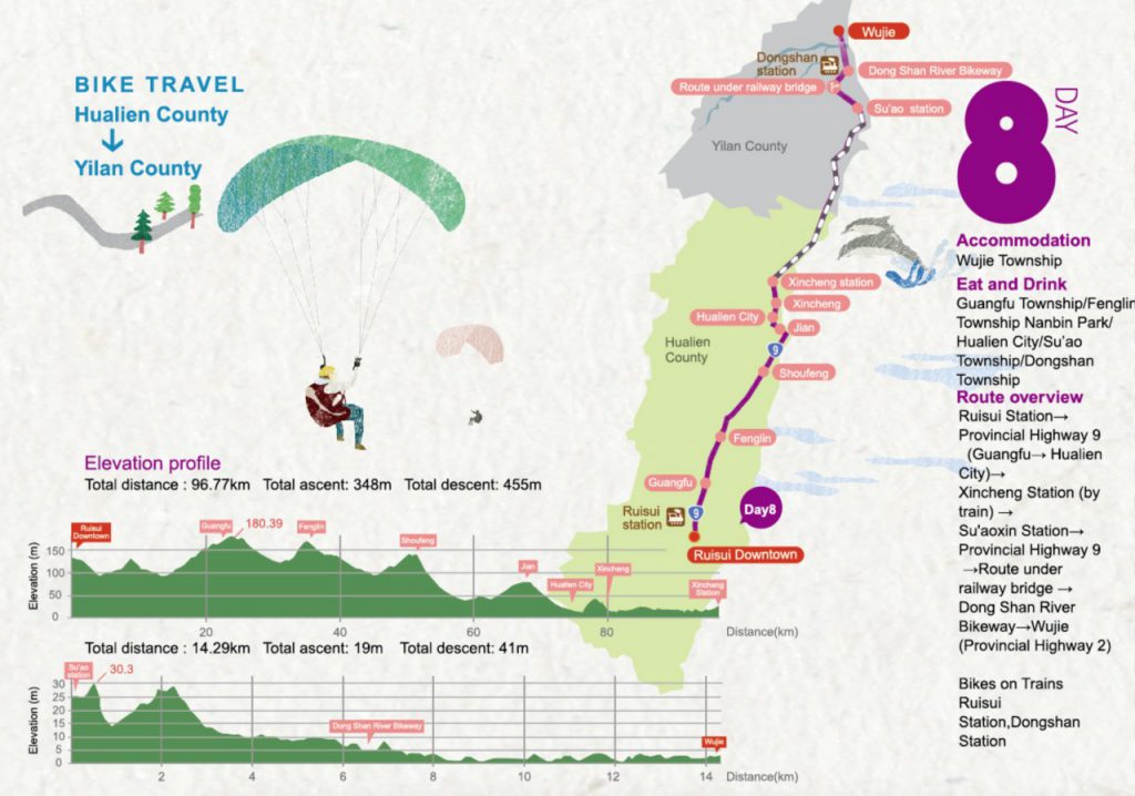
Route Overview
Ruisui Station → Provincial Highway 9 (Guangfu – Hualien) → train ride (Xincheng Station – Su’aoxin Station) → Provincial Highway 9 → Bike trail under the railway bridge → Dong Shan River Bikeway → Wujie (Provincial Highway 2)
Note: For Day 8, it is recommended by the route planner to take the train in order to skip the Suhua Highway, infamous for its heavy traffic and occasional falling rocks. Therefore we have followed the design and cut the GPX route into two parts.
GPX Routes
Part 1: Total distance 96.77 km | Total ascent 348 m | Total descent 455 m
- Garmin: https://connect.garmin.com/modern/course/33833447
- Velodash: https://cx6sm.app.goo.gl/2hrk
- komoot: https://www.komoot.com/tour/1023076770
Part 2: Total distance 14.29 km | Total accent: 19 m | Total descent 41 m
- Garmin: https://connect.garmin.com/modern/course/33851298
- Velodash: https://cx6sm.app.goo.gl/Gb8i
- komoot: https://www.komoot.com/tour/1023077752
NOTE: To use the routes, please install the App on your smartphone. The App will launch and load the route automatically after you tap the above links on your smartphone’s browser. For Garmin Connect, you can then use the APP to send the route to your garmin device. If your Garmin device is not purchased in Taiwan, you will also need make sure you have the Taiwan map on your device. Here is our blog post on this topic.
Disclaimer
We DO NOT own the graphic and information in this post – it all came from the Taiwan Cycling Single Portal built and maintained by the Ministry of Transportation and Communications of the Taiwan Government. This website is the authoritative source of information for all those who plan to do the around-the-island trip in Taiwan. It’s very useful, but unfortunately not very user-friendly in our opinion. Therefore, what we are trying to do here is to re-organize the information in a way that we find handy and mobile-friendly.
